Sunday, September 17, 2023

2023 CANYONLANDS ADVENTURE - IT WAS A GRAND DAY


DAY #9 – SUNDAY – JULY 10, 2023

 PAGE, AZ – KANAB, UT

191 – MILES / 2,766 – TOTAL MILES


We spent the night at the Best Western – Lake Powell in Page Utah. This was a really good hotel. My Room was clean and comfortable. The breakfast was basic but it featured a spectacular view of the Colorado River and the Arizona Desert. We had to have our luggage out by 6:30 and the breakfast area didn’t open until 7 a.m.

This hotel features a balcony that extends the length of the breakfast area so while I was waiting, I grabbed a cup of coffee and decided to take a walk and watch the sun come up. The morning sun really highlights the colors of the Arizona Desert.

By the time I finished up my morning walk, the breakfast area was open, and I joined a couple of others from our group and enjoyed breakfast with a view on the balcony. Nothing like breakfast with a view and good company.

We were scheduled to leave the hotel a 8 a.m. and surprisingly everyone was on the bus before 8 and well pulled out right on time. From the hotel balcony we could see our first stop of the day. So less than 10 minutes after leaving we pulled up to the Glen Canyon Dam.

At 710 feet high, the Glen Canyon Dam is just 16 feet shorter than Hoover Dam that stands 726 feet tall. Construction began on the dam in 1956 and it wasn’t completed until 1966. During construction more than 4,901,000 cubic yards of concrete were used. That concrete is still curing today and will take several more decades to completely cure.

Today The dam serves multiple purposes such as flood control on the Colorado River, and as a power generating facility for millions in Arizona, Utah and along the lower Colorado River Basin. Finally, it created Lake Powell, one of the Southwest Largest Recreation areas. Lake Powell is the second largest reservoir in the United State. Only Lake Meade that was created by the Hoover Dam, is larger.

Because we were so early, the Visitors Center wasn’t open and all we could do was walk around the area and take a few photos. This was a nice stop, but I would have liked to delayed our departure from the hotel about 30 minutes so we could have toured the Visitors center and Museum.

As it is we only spent about 30 minutes here before heading out to our next stop of the day, which was about an hour away. The drive from Glen Canyon through the Arizona desert was beautiful, and only our habitually late couple found it boring and as usual complained to those that would listen.

Anyway, about an hour after leaving the Glen Canyon Dam, we arrived at Marble Canyon and the Navajo Bridge.  Marble Canyon was created by the Colorado River and stretches from the North Rim of the Grand Canyon to near the Glen Canyon Dam in Page, Arizona. Marble Canyon is part of the Grand Canyon National Park.
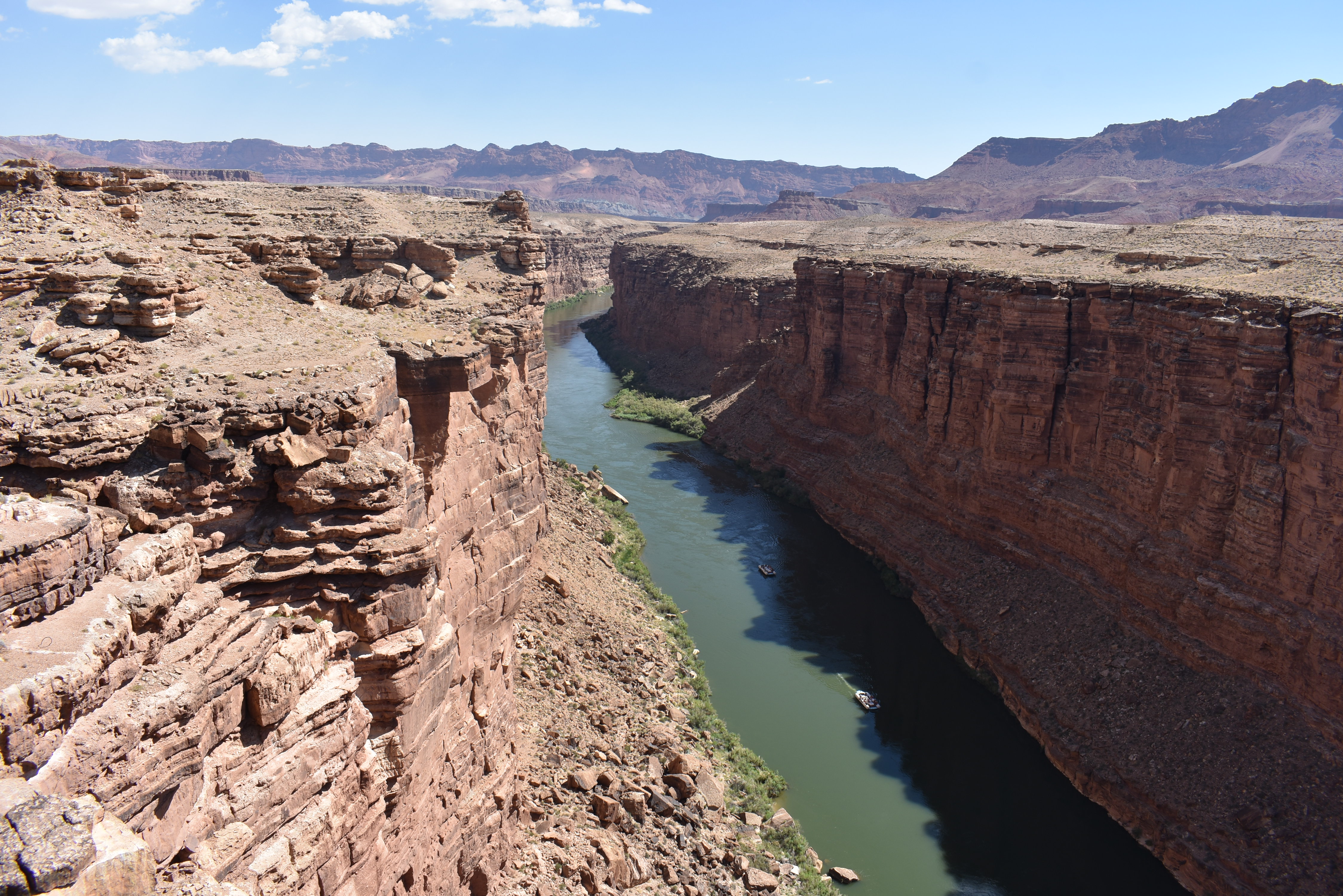
The Navajo Bridge spans the Colorado River which flows through the canyon more than 450 feet below. There are two spans here today. The original span was built in 1929 and is about 910 feet long. It carried vehicle traffic until 1995 with a new span was constructed. Today the Original 1929 span is used as a pedestrian bridge that affords visitors fantastic views of the canyon and river below.

While I was walking across the 910-foot bridge, I saw a large group of rafters making their way down the river under the bridge.  One of the volunteers at the visitors’ centers said rafting trips stretch for various length. Some put in at Page and raft down to the Bridge. The longest rafting trip available is a little over a weeklong and stretches from Page all the way through the Grand Canyon. Rafter on these trips spend the night in Tents and cowboy camp and cook along the way.

All total we spent about 45 minutes here at Marble Canyon and the Navajo Bridge. It was a good stop and one that Most of our group enjoyed.

From Marble Canyon we were off to our benchmark stop of the day. It took almost two hours to make the trip to the North Rim of the Grand Canyon. I have been to the South Rim of the Grand Canyon several times and no matter the time of year that I visited the South Rim was always crowded. I have heard that the North Rim is more remote, less developed, and not as crowded.

One the way to the Nort Rim we made a quick rest stop at the Jacobs Lake Inn and Store. This was a great stop that featured a large gift shop, general store, and a bakery. Several in our group including me, picked some really good cookies and pastries from the bakery. 

The Drive from Jacobs Lake to the North Rim took us another 45-minute. Along the way we passed a rather large fire and saw a number of firefighters beside the road.

After our stop at Jacobs Lake, it was another 45 minutes or so to the Grand Canyon Lodge on the North Rim. Michelle told us that we needed to be back on the bus at 3 p.m., which gave us two and a half hours to spend here.  That would give us enough time to do a couple of short hikes and still have time to grab lunch.

When we arrived, we soon found out that due to staffing shortages two of the three restaurants here at the north rim were closed. Only the Rough Rider Saloon was open, and it was crowded. So, I decided to delay lunch and hike down to the Bright Angel Point.

This is a moderately difficult half mile trail that stretches from the Lodge down to Bright Angel Point. Along the way you get spectacular views of the Grand Canyon.  It took me close to an hour to complete the hike because I kept stopping along the way to take pictures.

Back at the Lodge, I found the line at the Rough Rider Saloon had decreased some so, I got in line. The Rough Rider features soups, salads, and sandwiches. Nothing fancy and nothing all that great.  I had a $5.00 Hot Dog, a $4.00 cup of Soup, and a drink. This set me back almost $14.

After Lunch, it was getting close to the time that we would need to begin boarding the bus.  I still had time to visit the gift shop to pick up a few souvenirs. I also purchased another drink to take with me on the bus.

Right at 3 p.m. everyone was back on the bus, and we departed for the North Rim. On the way back the fire that we saw on the way in seemed to have increased with a larger smoke field. This time we actually saw flames off to the side of the road. I never did find out if this was a controlled burn or a wildfire.

On the way back out, we also stopped again at Jacobs Lake for a quick rest stop and more cookies and pastries. Then it was another hour and a half drive to the Hampton Inn in Kanab, Utah.

On the way to Kanab, when Michelle got reliable cell service Michelle found a restaurant in Kanab that said they could accommodate our large group. When we crossed into Utah, we also lost an hour and went back to Mountain Daylight Time. While it was only 4:30 in Arizona it was 5:30 when we arrived at the Hampton Inn – Kanab.

Upon arrival at the Hampton Inn, Michelle distributed our keys and gave us an hour to get settled. At 6:30 we were back on the bus for the short trip to Lotsa Mosta Pizza. This was a fast-food pizza joint where you ordered at the counter. There was a small dining area where we could eat but you could see that most of their business was takeout.

They had a limited menu, and I ordered a small sausage and Pepperoni Pizza. With the large number of orders from our group it took a while for them to complete our individual orders. My Pizza was average at best, but it was filling.

Back at the Hampton Inn I settled into my room and snacked on the Cookies that I had bought at Jacobs Lake. They were better than the pizza.

Knab is a small town that is the gateway to Zion National Park, which will be our first stop tomorrow. We are about to begin the part of this adventure that I am looking forward to the most. Our visit to the National Parks of Utah.

Sunday, September 10, 2023

2023 CANYONLANDS ADVENTURE - IT WAS A MONUMENTAL DAY


DAY #8 – SUNDAY – JULY 9, 2023

 DURANGO, CA – PAGE, AZ

323 – MILES / 2,486 – TOTAL MILES


This begins the second week of being on the road and basically marks the halfway point in this adventure. After riding the train down from Silverton, Colorado we Spent the night at the Hampton Inn in Durango, Colorado. The Hotel was very clean, and the employees were nice and helpful and if I ever get back this way I will consider staying here again.

While this is going to be a moderately long day mileage-wise as we will cover only about 350 miles. It does have the potential to be a long daytime wise, as we have several stops scheduled. For that reason, were told to be on the bus at 7:30 a.m.

Because our habitually late groups reverted to being late. This is getting a little old not only to me but to some of the others as it is the same two couples every time.

Because of our late couples, we didn’t leave the hotel until about 7:40. This wasn’t too bad as out first stop of the day was only about 40-miles away. Leaving Durango, we began gaining elevation as we made our way-out U. S. Highway 160. This was another beautiful and took us only about 30-minutes to reach the turn off to the Mesa Verde National Monument.

After turning off Highway 160 it was another 20-miles down the scenic drive to the Visitors Center. This 20-mile drive took us almost 40-minutes. But we finally arrived at the Visitors Center and were free to explore the National Park on our own for the next hour.

The Mesa Verde National Monument has some of the most notable and best-preserved cliff dwelling in the United States. Sometime during the late 1190s, after primarily living on the mesa tops for 600 years, many Ancestral Pueblo people began moving into pueblos they built into natural cliff alcoves.

The structures ranged in size from one-room granaries to villages of more than 150 rooms. While still farming the mesa tops, they lived in cliff dwellings, repairing, remodeling, and constructing new rooms for nearly a century. In the mid-1200s, the population began migrating to the south, into present-day New Mexico and Arizona. By the end of the 1200s, most everyone had migrated away.

It’s a pretty good walk from the Visitors Center down to the area where we can view the Cliff
Dwellings. While I was at the Viewing Area one of the Rangers was making a very interesting presentation about what life was like for the people living here those many centuries ago.

Most people think that cliff dwellings were single family homes, when I fact the dwelling that I was looking at was more like a small village. Inside the rooms of the Cliff Dwelling there were indeed living areas in addition to storage areas for food, water and the staples needed for everyday life.

Water was on thing that was in short supply and the people who lived here had to carry water from nearby sources. Some to these sources would dry up during the summer months and they had to roam farther and farther from their dwellings. It is thought that the lack of water may have been one of the reasons that the residents began to move to the south.

There are several of these cliff dwellings that are built into the mesa. The one that we got to see was called the Spruce Tree House.  One of the disadvantages of being on a bus is that we didn’t have the opportunity to take the complete driving tour and see the other dwellings.

This was a very interesting stop that was made even more interesting by being able to listen to the Rangers Presentation. I visited the gift shop and got me some souvenirs and a couple of drinks from the concession area.  Like most of the food and beverage vendors at National Park the prices are really inflated. A small cup of coffee and a small cold drink cost me over $6.00.  In fairness to the National Park Service, the vendors are private contractors and can set their own prices within the limits of their contracts.

Our habitually late couples struck again, and we were 15-minutes late pulling out of the Mesa Verde National Monument. The 20-mile drive back to Highway 160 took us about an hour. We stopped at Wal-Mart and a Denny’s in Cortez Colorado. Several in our group including our habitually late couples chose to walk up to the nearby Denny’s for lunch.

Our tour guide Michelle needed to stock up on bottled water at Wal-Mart. This Wal-Mart also had Subway and the rest of us figured it would be quicker just to grab something from Subway. Again, we were about 20-minutes late leaving Cortez.

About an hour and 50-miles later we arrived at the Four Corners Monument. I have been here before, back in 2018 during my three-week adventure around Arizona.

The Four Corners Monument is located on the Navajo Tribal Linds and is the only place where four states meet, Arizona, New Mexico, Colorado, and Utah. The monument is operated and managed by the Navajo Nation. where four states meet, Arizona, New Mexico, Colorado, and Utah.

The actual monument is a compass rose that is surrounded by open air vendors booths where you can purchase native artwork. The only facilities are pit toilets and porta johns that reek in the heat.

I was last here in late October and there weren’t very many people there and there was no problem getting photos and selfies at the monument. This time it was a little more crowded and there was a line of people Waiting to get pictures.

Around the monument are raised platforms where people can stand and get photos of the monument and the people from above. Michelle was kind enough to stand on one of the platforms and take photos of everyone in our group.

During our time at the Four Corner’s, we had no problems figuring out that we were no longer in the cool Colorado Mountains but in the hot desert of the Southwest. When we left Durango, it was 67 degrees and 82 degrees at Mesa Verde. Here at the 4-corners it was 96 degrees and pushing toward 100. Today in Phoenix it was going to be close to 110 degrees.

Back on the bus we headed toward our next stop in Monument Valley. I had hoped that we would travel up through Red Mesa and Medicine Hat. If we had taken this route, we would have come into Monument Valley from the North. This would have allowed us to stop at Forest Gump Point on Highway 163.

When I was here in 2018, I was able to stop and grab a few pictures at the Exact spot that Forest Gump Stopped running in the Popular Movie. When we mentioned it to John and Michelle, they both said that it was too far out of the way, so we took the more direct route down Highway 160 to Kayenta and then traveled North on Highway 163 into Monument Valley. The drive up from Kayenta was just as spectacular as I remember.

Once again Monument Valley is located on the Navajo Nation and is NOT a national park. We arrived at the Navajo Welcome Center on Highway 163 and were given only about 30 minutes to enjoy the magnificent beauty of Monument Valley.

From the Welcome Center we could see only a small portion of what Monument Valley has to Offer. We could see the Mittens, the three sisters, and the Elephant. What we couldn’t see was the Camel, and John Fords Point.

Thank Goodness, that I got to drive down into the valley back and 2018. During that Visit I got to see the amazing formations up close. I also got to see and stand on John Ford’s Point. The point gets its name from the famous motion picture director John Ford who filmed several movies here starring John Wayne including “The Searchers,” and “She wore a Yellow Ribbon.”

During filming of the Movies, John Ford and John Wayne stayed a Goulding’s Lodge which was located just across from the Welcome Center. I stayed there during my 2018 visit.

While we were stopped at the Welcome Center several in our group tried once again to convince John and Michelle to make the drive-up Forest Gump Point. The point was only about 15-miles further north on Highway 163. But they said it would take too long and we were already behind schedule. This is one of the draw back of traveling on a bus. You just can’t deviate from the schedule.

We wrapped up our visit to the Welcome center and headed back south on Highway 163, retracing our route back to Kayenta.

Back in Kayenta we stopped at Burger King. Michelle had told us there were no restaurants anywhere close to our hotel and Burger King would be our supper stop. I had stopped at this Burger King back in 2018. During that visit I noticed a couple of Display cases in the seating area.

Before leaving I checked out the cases and found that it was a display paying tribute to the Navajo Code Talkers of World War II.  During My 2018 visit I was able to talk to one of the young ladies who worked here. Come to find out some of the artifacts in the case belonged to her grandfather.

I really enjoyed talking to her and she seemed proud to be able to talk about her grandfather.  It was wonderful to see such a young person talk about her relative with such pride.

As I was getting off the bus one of our group, Miss Nancy, told me that she didn’t really want to eat at Burger King and asked if I would walk with her to the nearby Arby’s. I gladly did and we had a nice visit over supper. Miss Nancy was a retired schoolteacher from West Virginia. She had taken a couple of other bus trips and was a very nice lady.

After supper with Miss Nancy at Arby’s we walked back to Burger King.  The Code Talker display was still there, and I enjoyed seeing it again.

Back on the Bus we headed toward our nights lodging about 100 miles away in Page, Arizona, The 100-mile drive took up a little over an hour and 45-minutes and the scenery was still great.

While we were driving My cell phone changed time several times. Then it dawned on me what was happening. Arizona did not observe Daylight Savings Time, but the Navajo Nation did. As we were driving, we passed in and out of the Navajo Nation several time. Kenyata was on the Navajo Nation and was observing Mountain Daylight Savings time but Page was not, so we were on Mountain Standard Time. So technically arriving in page we are three hours behind the East Coast and on the same time as California.

This Arizona Time situation created some confusion with our group. When Michelle Told us we need to be on at 8 a.m. in the morning. The problem was some of our clocks had updated to standard time while others hadn’t.  Since the hotel and the attractions around us were operating on Standard time (3-hours behind the east coast) we would be back on the bus at 8 a.m. Mountain Standard Time. We would lose the hour again when we crossed into Utah.

We arrived at the Best Western in Page, Arizona at 6:15 p.m. Mountain Standard Time. It took Michelle a while to get our keys together and distributed. The hotel overlooked the Glen Canyon Dam and the Colorado River. The views were once again amazing.

One of the sites that I had on my list was Horseshoe Bend in the Colorado River which is located just south of Page. The Parking Area for Horseshoe Bend is about 3-miles from my hotel, once at the parking area it’s a half mile walk out to the overlook. The walk is through loose sand and is rated moderate to difficult.

I looked on both UBER and LYFT to see if I could get a ride down to the parking area. But Page is a small town and neither Lyft nor Uber operate in this area. Horseshoe Bend will have to wait.

Tomorrow we are off to Marble Canyon, The Navajo Bridge, and the Grand Canyon. It will be another full day.

Sunday, September 3, 2023

2023 CANYONLANDS ADVENTURE - TRUE GRIT & RIDING THE DURANGO SILVERTON RAILROAD


DAY #7 – SATURDAY – JULY 8, 2023

 MONTROSE, CO. – DURANGO, CA

106 – MILES / 2,163 – TOTAL MILES

This marks the 7
th Day of my great Canyonlands Adventure, and it begins here in Montrose, Colorado. This is one of the days that I have looked forward to since I started planning this trip. It was here in the high mountains of Colorado that My all-time favorite movie was filmed. In 1969, John Wayne, Kim Darby and Glen Campbell filmed the Academy Award Winning Movie, “True Grit,” here in this area.

The Hampton Inn here in Montrose was a very nice Hotel. My room was clean and well attended and we enjoyed a very good breakfast. Once again, our habitually late people surprised us by being on the bus a few minutes early.  This allowed us to leave the Hampton Inn right on time at 8 a.m.

The drive from Montrose down to Ridgeway was very scenic although I was told the best was yet to come.  I had hoped that we would stop in Ridgeway because several scenes from True Grit were filmed here.


The exterior courthouse scene was filmed here along with the Hanging Scene and the scene where Marshall Rooster Cogburn (John Wayne) arrived with a paddy wagon full of prisoners. That original Paddy Wagon Is still on display in the Ridgeway Town Park.

The Railroad Depot where Mattie and her companion Yarnell Poindexter first arrived is also in Ridgeway. Just about 20-miles or so out of Ridgeway is Last Dollar Road. It was there that the opening and Closing scenes of the movie was filmed at the Ross Ranch.

About 20-miles east of Ridgeway in a very remote area is Deb’s Meadow. It was there that Rooster faced off with Lucky Ned Pepper. It was here that one of the all-time great movie scenes took place.

With Lucky Ned and his men on one side of the meadow and Rooster on the other side, Rooster tells Ned that he intends to kill him or “see him hanged in Fort Smith at Judge Parker’s convenience, what’ll it be?”

Ned Replies, “I call that mighty bold talk for a one-eyed fat man.”

Rooster’s reply was classic, “Fill your hands you son of a bitch.”

And with that they went Charging across the meadow, guns a blazin’.

But we didn’t stop in Ridgeway. I hope to return to this area on my own in the not too distant future to visit as many of the True Grit Sites as I can.

The drive across the mountains between Ridgeway and Ouray is known as the Million Dollar Highway. Most people think it is because of the “Million Dollar Views.” But it’s not, it is called the Million Dollar Highway because it costs more than a million dollars a mile to build. Not the less it was the most spectacular of the trip so far.


We did stop for our morning break in Ouray which allowed some of our group to get in a little shopping. For me is allowed me the opportunity to walk up to the Ouray Courthouse.  This was the courthouse where the Interior scenes of Judge Parker’s court Took place. It is in this courthouse that Rooster testified about killing the Whorton's and it is where he first meet Mattie Ross.

It being Saturday the Courthouse, which is still in use, was closed and I couldn’t see the True Grit Courtroom. But again, I hope to return in the Not-too-distant future.

I spent the rest of my time in Ouray, walking around town taking photos of the old building and buying a few souvenirs. After about an hour it was time to get back on the bus and continue our journey toward our next stop in Silverton.

It is only about 35-40 miles from Ouray to Silverton, but the drive took us through more spectacular scenery. Up and down the mountains filled with switchbacks, the drive took us about an hour and a half to complete.

Arriving here in Silverton, we say goodbye to our bus and our driver John for the rest of the afternoon.  Once he lets us off in the center of the historic town, he is off to Durango where we will meet him later this evening.

After we spend a couple of hours shopping and having lunch, our group will board the Durango-Silverton Narrow gauge Railroad for the three-and-a-half-hour trip to Durango. It will take John a little over an hour to make the 50-mile drive.

It’s a little after 11 a.m. when John, drops us off and we have a little better than 3-hours to kill before we board the train. Everybody scatters and pretty much goes their separate way. I decided to walk around this old and historic silver town that I set in a high valley between the snowcapped peaks of the Rocky’s.

Silverton is the county seat of San Juan County, that is named for the San Juan Mountains that surround the Town. Most of the peaks surrounding the town at mor than 13,000 feet above sea level. There are 53 Rocky Mountain Peak in Colorado that exceed 14,000 feet and 7 of those peaks are less than 15 miles from Silverton.

Silverton got its start in 1874 as Baker Park, when gold and silver was discovered in the mountains and along the Animas River. The tent’s that form the community housed everything from Saloons and Brothels to Essay Office and private residences.

The remoteness of the community made it difficult to get the ore that was being mined here out of the Valley. So, the Denver and Rio Grande Railroad set about laying tracks along the Animas River from Durango to Silverton. By 1885 more than a Million dollars a year was being mined around Silverton. From 1882 until 1918 the Silverton Mining area produced more than $65 million dollars.

As the years passed, the mines began to play out and in 1991 the Sunnyside Mine, the last operating mine in the area, closed. By then Silverton had already begun the transition from Boom town to a Tourist destination.

Today the main tourist attraction is the Durango-Silverton Narrow Gauge Railroad. The entire town has been designated a National Historic Landmark. Brothels and Saloons have been replaced by shops, cafes, and restaurants. The Local Historic Society, the Mining Heritage Center and the Old County Jail as a Museum.

Having a few hours to kill, I walked around town and decided to visit the old Jail Museum. As I entered the museum, I was greeted by a wonderful gentleman who wasted no time in giving me a brief history lesson of not the Old Jail but the mining Museum that is included in my admission. He seemed to sincerely enjoy sharing the history of the area.

I began my tour in the old jail which was built about 1902 and while not as harsh and primitive as some of the old west jails that I have visited, I wouldn’t want to be a guest here.

After I completed the tour of the jail, I walked down a couple of flights of stairs into an under-ground basement that had been made to look like an early Silverton Mine.

The Mining Museum was outstanding. It took you on a trip from the early days of mining all the way through 1991 when the last mine closed.  I love these little (this one is not so little) local museums, but this one was way more than I expected. I ended up spending over an hour here, it was worth every minute.

By taking longer at the museum than I had planned I set about finding a place to have lunch. As I was walking back down historic Blair Street, I ran into Jenny, Mary Ann, and a couple of other ladies from my group. They told me that they had lunch at Natalia, and it was good and quick.

So away I went. There were a couple of other folks from my tour group having lunch at Natalia’s, but their table was full, so I ate by myself.  I had a half pound burger and fries. Mary Ann and Jenny were right. The food was good and served quickly. 

After lunch, I still had a few minutes left before it was time to board my train for the ride to Durango.  The train and locomotive had arrived and had pulled up to the head of Blair Street where I joined a crowd of tourists taking photos and selfies.

Despite the elevation it was a rather warm day and I decided to stop by a little ice cream parlor and have a double scoop of peach ice cream.  On the way back to the train I stopped at the Shady Lady Saloon and took a selfie with one of the Shady Ladies.

At a little before 2 p.m. the conductors began boarding the train. All our group were seated in the same car and right at 2 p.m. we pulled out and began our 3-and-a-half-hour ride to Durango.

The Durango & Silverton Narrow Gauge Railroad has been in continuous operation since 1882. During the 45-mile trip the train is only able to reach a top speed of 22 mph and travels along the Animas River and through some of Colorado’s most scenic back country.

While the scenery was spectacular, it was a long and slow journey and some of our group began to complain about being trip taking too long. But I enjoyed the trip but must admit that I was ready for supper when we arrived in Durango.

Upon arrival in Durango, Michelle, our tour guide, told us that we had an hour to grab supper before boarding the bus for the short trip to our hotel. Being Saturday Night, Durango was crowded with locals and tourists so most of the sit-down restaurants either had a waiting list or were so crowded that it would take more than an hour to get our food and eat.

So, a few of us walked to a nearby McDonalds. We ordered from the Kiosk and got out food quicker than those opting to order from the counter. After our quick supper we walked around town, exploring some of the shops and picking up a few souvenirs.

Finally, it was time to board the bus and make the short drive to the Hampton Inn. One thing that John did when He arrived in Durango was deliver our Luggage to the rooms and pick up our room keys. So, on the ride to the hotel, Michelle passed out our keys.

Once at the Hotel the only thing we had to do was head to our room. Bringing another great day to an end. Tomorrow, we leave the cool Colorado Mountains for a few days and head down toward the 4 Corners and into the heat of Arizona.

Sunday, August 27, 2023

2023 CANYONLANDS ADVENTURE - A ROYAL GORGE AND A BLACK CANYON


DAY #6 – FRIDAY – JULY 7, 2023

 CANON CITY, CO. – MONTROSE, CO.

180 – MILES / 2,057 – TOTAL MILES


On Day #6 of my Great Canyonlands Adventure, we will make our way across the continental divide and transition from the front range of the Rockies to the West Side. We pulled out of the Best Western in Canon City about 5-minutes after 8 a.m. Mountain Time.

We headed west on Highway 50, and almost immediately after leaving town we began to climb up the mountain toward our first stop of the day. The drive up, like everything in Colorado, is a scenic one. About 10-miles west of town we make a left-hand turn onto Colorado Highway 3A.

Five Miles later we arrive at the Royal Gorge Bridge which is another one of My Bucket List Destinations. We arrive about 8:40 a.m. and access to the bridge and attraction aren’t available until 9 a.m.

But there are several overlooks and scenic views available from the parking lot.  While walking around I see a deer grazing in the valley below and off in the distance there are several big horn sheep. I managed to get a picture of the Deer but just as I was focusing in on the sheep a bunch of noisy kids scared them and off, they went.

There was also an old Rio Grande Steam Locomotive and tender on display overlooking the gorge carved by the Arkansas River.  This Denver and Rio Grande locomotive was built in 1902 by the Baldwin Locomotive Works of Pennsylvania.

It is a standard gauge 2-8-0 and rebuilt by the Denver & Rio Grande in 1930 as a 2-8-2 and became the Denver & Rio Grande #499. In May of 1999 it was acquired by the Royal Gorge Bridge Park and has been on display here ever since.

Right at 9 a.m. Michelle, our tour guide secured and distributed our tickets, and we were free to roam around the Royal Gorge. The first time most of us did was begin our walk across the 1,260-foot bridge that spans the gorge carved by the Arkansas River some 950-feet below.

The views of the river and the gorge from the bridge are spectacular. While I was walking across the bridge, I watched the Royal Gorge Scenic Railroad make its way along the river below. 

While I am not fond of heights, I had no trouble walking across the bridge or looking over into the canyon below. It took me about 45 minutes to walk across the bridge and back because I stopped often to take in the magnificent views and to take photos.

There are a couple of other attractions here at the gorge that some in our group took advantage of. One is a zip line that sends you speeding across the gorge.  Now this wasn’t for me, but one member of our group did pay the extra fee and take the heart pounding ride across the gorge.

There is also a gondola that carries visitors across the gorge.  Again, while I am not a fan of heights, I decided to take the gondola ride across the gorge.  This was a spectacular ride that afforded me amazing views of the Bridge, the gorge, and the river below. It was a grand ride, and I am so glad I did it. But there is no way that I would do the zip line.

We spent a little more than two hours at the Royal Gorge, and it was a fantastic stop. A little before 11 a.m. we made our way back to U. S. Route 50 and continued our journey west toward the Continental Divide.

A little over an hour later we arrived at Salida where we decided to stop a McDonalds for Lunch. The one thing about traveling by tour bus is you can’t just pull into the parking lot and park. You can’t just park on the side of the road either. You must find a place large enough to safely discharge the passengers.

Here in Salida there was a parking lot in front of a NAPA Auto Parks Store big enough to accommodate our bus. Our Driver John pulled into the lot with the intent of letting us off and then moving on to park elsewhere.

Just as we stared t to get off the bus a man from inside the NAPA store came out and started to rant and rave that John had to Move the bus. John tried to explain that he was just staying long enough to discharge his passengers. But the Irate guy wouldn’t listen, insisting that John Move the Bus immediately.

We did finish getting off the bus and made our way into McDonalds. John moves the bus to a side street almost directly behind the McDonald.

One more thing about traveling by bus. When you drop 40 plus people unexpectantly in on a restaurant you can expect slow service and confusion. But I must say that this McDonald’s was well staffed and handled our rush in fine fashion. The food was served quickly, and our orders were correct. This was a well-managed and well-prepared McDonalds.

As efficient and nice as McDonald’s was, the encounter with the Irate NAPA Employee left a bad taste in our mouth and was a stain on the town of Salida.

The town of Salida sits at the eastern foot of the Rocky Mountains. As we left the McDonald’s and continued west, we could see our next destination directly in front of us. Almost immediately we began to climb the eastern slope of the Rockies.

In a little more than 30 minutes, we climbed from 7,000 feet in Salida to 11,300 feet at Monarch Pass. This was our next stop of the day.

Monarch Pass sits at an elevation of 11,312 feet on the Continental Divide and as we got off the bus there was a definite chill in the air. We had gone from 82-degrees a few minutes earlier in Salida to 54-degrees here at Monarch Pass.  The wind was also blowing, 20-30 mph.

As I walk around snapping pictures of the still snow-covered peek, the wind about blows me away.  There is a good-sized building here at the Pass that houses a gift shop, and snack bar. 

Monarch Pass is on the Continental Divide Trail which is a 3,000-mile hiking trail that stretches from
the Mexican Border in New Mexico to the Canadian Border in Montana. It is one of the trails in the United States Triple Crown. The others being the Pacific Crest Trail that runs from the Mexican Border in California to the Canadian Border in Washington State. And the Appalachian Trail from Georgia to Maine.

The gifts shop here, has a large selection of Hiking equipment, and supplies that day, weekend and thru hikes can purchase. While I was in the Gift Shop two northbound thru hikes came in and I was able to talk with them for just a bit. The Started their Hike back in early April and were hoping to finish sometime toward the end of September or Early October. They did say they were behind because they had to take a 10-day break a week or so ago because of an injury.

This was their first attempt at thru hiking and eventually they want to complete the Triple Crown. I treated them to some “trail magic” a couple of drinks and some protein bars and wished them well on the rest of their adventure.

 Before getting back on the bus, I bought a couple of t-shirts and grabbed a cup of coffee. Our next stop was about 100 miles away, so I also grabbed a few afternoon snacks.

Leaving Monarch Pass we began our descent down the western slope of the Rockies. It was slow going but the scenery was beautiful. Arriving in the Valley on the western slope of the Rockies we ran alongside the Gunnison River which has been dammed up to form a beautiful lake.

Two and a half hours after leaving Monarch Pass, we arrive at Black Canyon National Park, which is our next stop of the afternoon.  We arrive at the South Rim Visitors Center and begin our 45-minute visit to this amazing National Park.

The National Park contains the deepest and most dramatic section of the canyon. At its deepest point the Gunnison River is more than 2,700-feet below the rim of the canyon. Black Canyon gets its name because the deepest parts of the gorge receive only about 30 minutes of direct sunlight each day.

Because I have very limited time here, I take the short half mile hike down to the South Rim Trail to Gunnison Point. Here you get to see and appreciate the true delph of the canyon and its rugged beauty.

I

I must say the hike down was a heck of a lot easier than the climb back up. Making my way back to the top was a bit of a chore for a fat man with bad knees. But I eventually made it and had time enough to stop at the Visitor’s center to get my National Park Passport Stamp and a couple of souvenirs.

By the time I finished up in the Gift Shop it was time to get back on the bus and head to out final destination. It was about a 25-mile drive to Montrose and the Hampton Inn where we would be spending the night.

Since there were no restaurants close to the Hampton Inn, Michelle (our tour guide) had called ahead and made arrangements for supper. So before getting to our hotel we stopped at Jimmer’s BBQ, Burgers, and Beer in Montrose.

Jimmer’s was ready for us when we arrived, and our large group was immediately seated in an area they used for large groups that was away from the main dining area.  By the time our servers had taken out drink order they had set up an all you can eat BBQ buffet, consisting of pulled pork and ribs, baked beans, slaw, and a salad bar. They also treated us to banana pudding and peach cobbler for dessert.

This was by far the best food and service that we enjoyed on this trip. It was outstanding.

After we had eaten our fill and were getting ready to leave, the owner stopped by to thank us for coming and wished us safe travels. If I ever get back to Montrose, Jimmer’s will be my go-to place for a fine meal.

It was just a short two-mile drive to the Hampton Inn. Upon arrival Michelle quickly obtained and distributed our room keys. The meal at Jimmer’s and the quick check in at the Hampton Inn was the perfect ending to a great day. Tomorrow is what I am calling my True Grit Million Dollar Day. This adventure just keeps getting better and better.